GMA and UK Hydrography Office Partner to Bolster Ghana's Maritime Mapping Capacity
This initiative, led by the Ghana Maritime Authority (GMA) and the United Kingdom Hydrographic Office (UKHO), aims to facilitate knowledge sharing and collaboration by coordinating efforts to enhance adequate charting (mapping) of Ghana’s waters. 
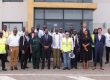
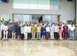
Workshop
Speaking at a hydrography governance workshop in Accra on Monday, November 3, 2025, the Minister for Transport, Joseph Bukari Nikpe emphasized that accurate mapping of Ghana’s waters is not just a technical requirement, but an essential foundation for national prosperity.
The workshop brought together maritime sector stakeholders from the academia, meteorologists, geomatics, and ocean experts to deliberate on legislative and regulatory changes required to formally establish the NHO, funding, equipment, and technology, along with funding, equipment, and technology.
Hydrography is the science of creating the safe ‘road maps’ for the sea, ensuring every vessel from massive cargo ships to local fishing boats knows the exact depth, avoiding underwater hazards like hidden wrecks or rocks.
The Minister highlighted the critical role of shipping, noting that the vast maritime transport network, which moves goods, energy, and commodities, requires efficiency and safety to keep the national economy connected to global markets.
“Hydrography provides the means to unearth the potential of the oceans,” the Minister stated, adding that “sustainable blue growth depends on safe, efficient and effective shipping.”
Mr Nikpe warned that poorly charted areas have serious implications for every Ghanaian and the cost of doing business.
“Inaccurate maps increase the risk of accidents, which can lead to severe environmental damage, higher insurance premiums for goods, less efficient loading of ships as well as longer and more expensive shipping routes”, Mr Nikpe said.
While expressing profound gratitude to the United Kingdom for their invaluable support, he issued a rallying call, urging all stakeholders present to “put their shoulders to the wheel” and wholeheartedly support Ghana’s unified hydrographic effort through the successful development and launch of the National Hydrographic Office.
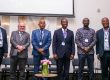
GMA
The Director-General of the GMA, Dr Kamal-Deen Ali (Naval Capt Rtd), emphasized the profound importance of hydrography for informed decision-making within the blue economy and ocean governance. 
Dr Ali underscored Ghana’s obligations as a member of the international community under crucial instruments like the International Convention for the Safety of Life at Sea (SOLAS) and the United Nations Convention on the Law of the Sea (UNCLOS).
“For this reason, we must strengthen our national capacity in hydrography, and the workshop provides a pathway for collaboration and the development of a National Hydrographic Office,” the DG said.
The Chief of the Naval Staff, Rear Admiral Godwin Livinus Bessing, in his remarks said that the Ghana Navy has taken deliberate steps to build a professional hydrographic capability, viewing it not as a standalone goal but as a strategic enabler for safe navigation, economic development, and national security.
He said that has led to the formal establishment of the Navy’s Hydrographic Unit, while a robust capacity-building programme is underway, of which 10 officers have completed formal, high-level hydrographic training (both Category A and B certifications) in the United Kingdom and India.
UK Commitment and Royal Navy Support
The Defence Attaché at the British High Commission, Commander Richard Walter’s commended Ghana’s commitment to advancing hydrographic governance. He also announced the Royal Navy will donate equipment and a survey motorboat to directly support Ghana’s hydrographic initiatives and the development of its future National Hydrography Office.